Home
레포트 트레이드
전공서적 본문검색
캠퍼스톡
AI 자소서
채용공고
로그인
1:1문의
전체
레포트
PPT 템플릿
정리노트
족보
논문
자기소개서
기타
자료등록
장바구니
관리
카테고리
전체
>
전체
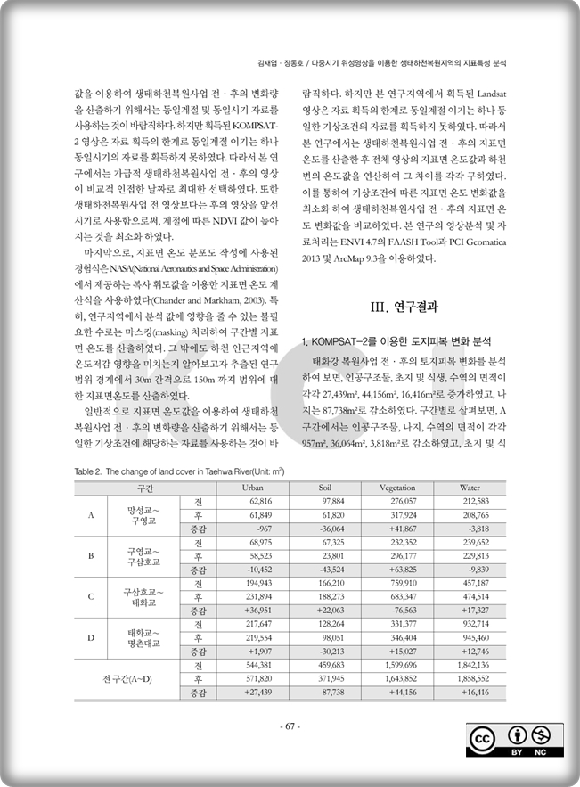
다중시기 위성영상을 이용한 생태하천복원지역의 지표특성 분석
소개글
Publish: Journal of The Korean Geomorphological Association Volume 22, Issue1, p63~73, March 2015
태그
land-cover
NDVI
surface temperature
satellite imagery
ecological stream restoration
저작시기
2015-03월
등록일
2016-08-26
파일형식
pdf
페이지
11페이지
가격
0원
다운로드
장바구니
관심자료
최근 본 자료
추천 연관자료
Seasonal effectiveness of a Korean traditional deciduous windbreak in reducing wind speed
Unmanned Aerial Vehicle Recovery Using a Simultaneous Localization and Mapping Algorithm without the Aid of Global Positioning System
Simulating three dimensional wave run-up over breakwaters covered by antifer units
A Comparative Analysis of South Korean Newspaper Coverage on Climate Change_Focusing on Conservative, Progressive, and Economic Newspapers
내담자의 내현적 자기애와 부정적 전이 및 작업동맹 간의 관계